
“On the Road to Nowhere: The Future of Urban Highways in Upstate NY” 5/26 Recap

The highways are coming down. It’s no longer a question of “if” but “when?”
Buffalo, Rochester, Syracuse, and Albany are all reconsidering the legacy of their urban highways—and coming up with plans to ameliorate the catastrophic consequences these hulking piece of misplaced infrastructure have laid upon their communities. With President Biden’s historic Transportation & Infrastructure bills looming in the background, the time is right for such a community-led reconsideration. How can we finally flip the script and redesign our cities’ landscapes not for the private automobile traveling at 65 MPH, but for people, greenspaces, and equity?
To open our panel, Ben Crowther of the Congress for New Urbanism and manager of CNU’s Highways to Boulevards and Freeways Without Futuresinitiatives helped us contextualize this moment within the national movement to dismantle and redesign urban highways. We then heard from representatives from four Upstate NY metro regions about each community's journey towards urban highway transformation. Such inter-city dialogue and best practice sharing is critical in solving these complex community design problems, and the time is certainly now to tackle this issue.

The day after our event, the NY Times ran a cover story on Urban Highways, "Can Removing Highways Fix America's Cities?" in which both Rochester and Syracuse were highlighted. Then, this week CNU announced the Freeways Without Futures 2021 Report which profiles 15 promising projects nationwide, including four (!) in Upstate NY.

Construction of I-395 in Miami: "Like a Tornado hit the city"
PAT FAHY, NYS Assemblymember from District 107 and longtime champion of reimagining I-787, opened our event with a tone of optimism, after several ongoing years of frustration: "Here in Albany there is a real coalescing around rethinking the waterfront," she said. "We have to ask three things: what these projects might cost, what we can do in the short term versus the longterm, and what is the economic impact of such projects."
–
BEN CROWTHER, of the Congress for New Urbanism and project manger for the Highways to Boulevards and Freeways Without Futures initiatives, provided some national context behind this watershed moment for transforming urban highways. He highlighted 15 national projects where highways had already been replaced with livable infrastructure, identifying the key benefits of such initiatives in three categories: expansion of the public realm, robust economic gains, and an emphasis on a healthy urban environment.
Mr. Crowther began with some history. "Before we talk about these transformations, we have to understand first how we got to this point," he said. "The story of highway removal starts with the story of highway building." He& said that the total number of residents nationwide that have been displaced by highways over the years is hard to calculate, but is well over one million. "This is state-sanctioned destruction of communities and landmarks," he said.
He stressed that in order to successfully bring down highways, one should not just talk of removal, but advocate for building assets rather than simply tearing down a liability. "What can a community build instead of a highway?" he asked.

Left: San Francisco's Embarcedro Freeway, removed after 1989 earthquake. Right: San Francisco's new waterfront.
Yet challenges remain even after a highways comes down. He cited Mandela Parkway in Oakland as an example where rising home prices post-highway removal displaced original residents. "Removal of highways has very real potential to cause displacement through gentrification," he said. "Decision makers must be intentional about protecting existing resident.
Going forward, Mr. Crowther stressed the involvement of the community.
Highway removal needs to be really driven by and designed in partnership by the communities that live around them. What do they want the future of the corridor to be?
—

STEPHANIE CROCKATT, Executive Director of the Buffalo Olmsted Parks Conservancy, the first coordinated urban park system in the country, described the amazing coalition work happening in Buffalo around confronting the destructive legacy of its urban highways and envisioning a brighter future.
One of the most prominent of these highways is the NY-198, the Scajaquada Expressway, which separates Buffalo State from the Scajaquada Creek waterway, cuts through the heart of Delaware Park, and has spliced the communities of Trinidad and Hamlin Park. There has been along history of back and forth between the community, the city, and the state DOT, with shifting scopes, budgets and timelines. In part to address these challenges and to empower the community's input, the Scajaquada Corridor Coalition was formed by a number of civic and community organizations, including the Buffalo Olmsted Parks Conservancy.

SCC Rendering: Facing North-West on the Kensington Expressway, between Sisters Hospital and Canisius College.
Part of Ms. Crockatt's role is to speak on behalf of the parks as a public space and community ecological asset gutted by the expressway. "We often say six rows of trees became six rows of traffic," she said.
The coalition has recently released a number of visionary renderings and a new timeline for highway reimagining removal has been set, though this was delayed by Covid-19. Like many, Ms. Crockatt finally sees everyone getting on board the same process, and the SCC's role in this collective visioning has been critical.
_
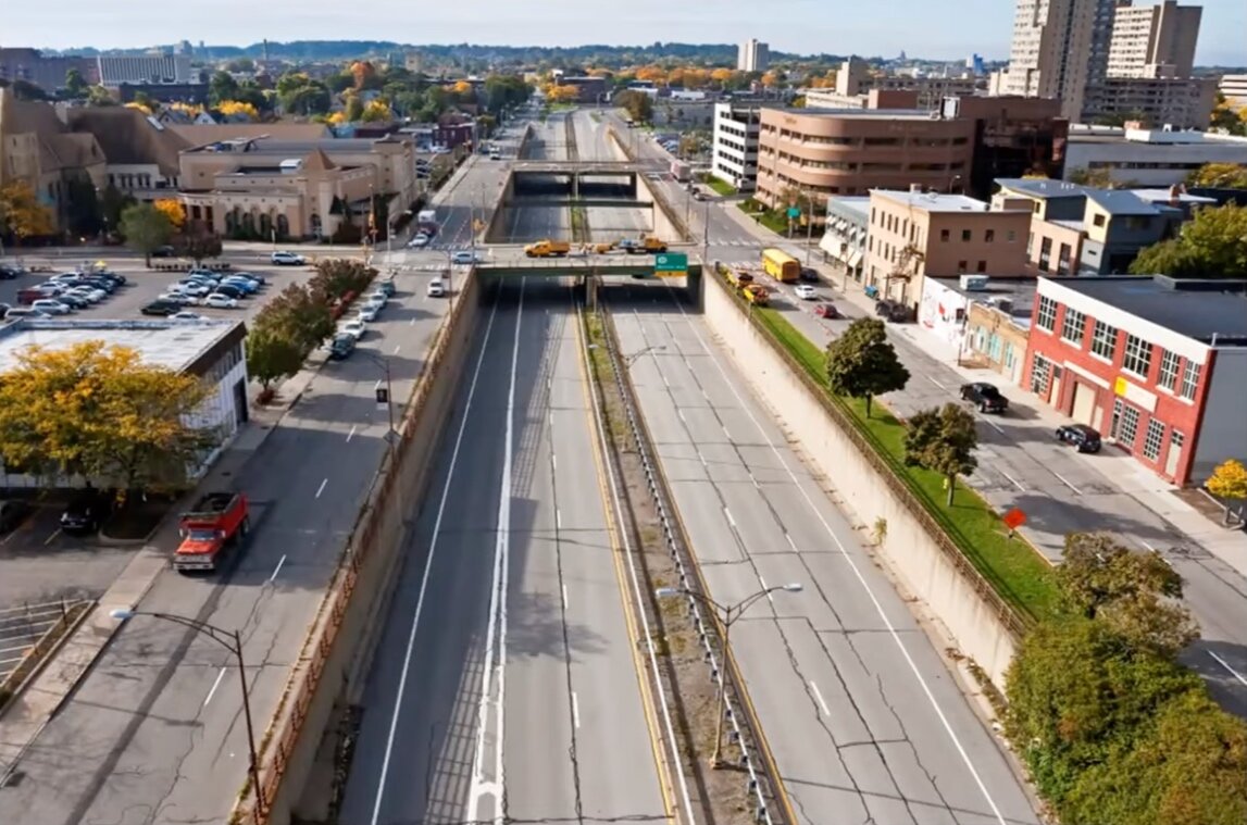
ERIK FRISCH, Manager for Special Projects for the City of Rochester, narrated that city's progress as it has been transforming its inner loop highway section by section. Underutilized, incredibly destructive and expensive to maintain, the inner loop has long been the bane of the city, and plans were in place all the way back in 1991 for its removal, "Which was quite visionary for its time," said Mr. Frisch.
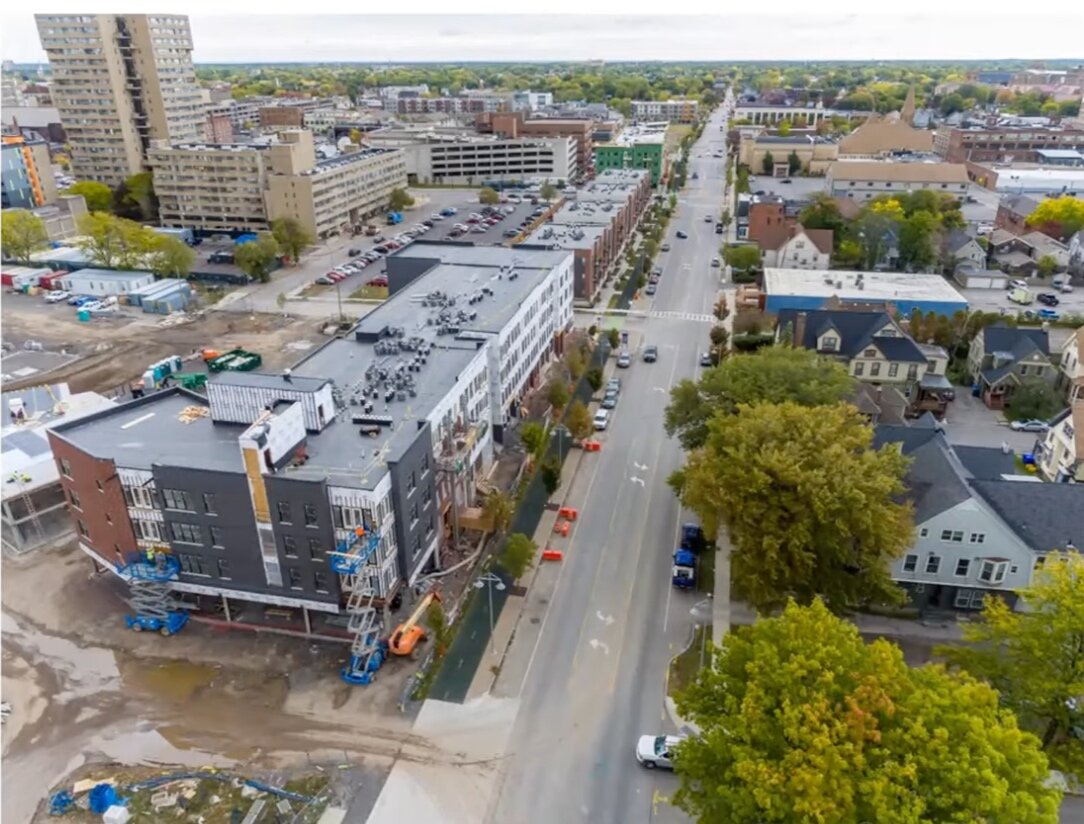
Due to this head start, Rochester is the only one of the upstate cities that has actually completed a highway removal project, the Inner Loop East, which was infilled and replaced with Atlantic Ave. The city is in the process of building over 500 units of new housing, over half of which are affordable or supportive units, 20,000 sq. ft of retail space, and ground has just been broken for a Museum of Play that will anchor a Neighborhood of Play.
Given the completion of the project, Rochester is one of the few cities that actually has access to seeing realtime results of the project's benefit-cost ratios. The numbers coming in are incredibly favorable. Studies show a large influx of cyclists and pedestrians since the highway's removal as well. "Beyond the $300 million of investment, what better way to measure success than the presence of people. When you remove this barrier and create wide sidewalks and quality bike facilities, the people will come."
The success of Inner Loop East has given momentum for the city's next project, the Inner Loop North. "At its heart, this project is all about equity," said Mr. Frisch. "We established a racial equity subcommittee and a racial equity analysis." These innovative metrics, combined with comprehensive community engagement, will be critical to actual designing solutions that both take in account the community's needs but also address the ongoing socioeconomic and racial destruction of these infrastructure projects.
—

JAY ARZU, Ph. D Student at UPenn's Stuart Weitzman School of Design and former Transportation & Equity Research Fellow for the Congressional Black Caucus Foundation, addressed both Rochester and Syracuse in his presentation.
Mr. Arzu was on Rochester's Inner Loop North Racial Equity Subcommittee and worked closely with the contractors trying to introduce racial equity into the city's transportation analysis, where such questions of equity have often been absent. "We were boggling our heads to create racial equity metrics in traffic studies," he said.
Robust, multilayered community engagement through surveys, charrettes, and multiple meetings were essential. "Why are we replacing this highway if the people living adjacent to this highway are not going to see an uptick in the quality of their lives?" said Mr. Arzu. The subcommittee also looked closely at land use—what percentage of land was used for transportation, commercial, and community development. "We wanted to bring racial equity not just into the design but make it a key holistic part of whole the development process."
Like others, Mr. Arzu stressed that thinking about community resilience after highway redesign was critical. "We're planning from the beginning," he said "We're planning for people in the neighborhood to remain."

Making racial equity a key part of the whole development process.
Mr. Arzu also introduced us to the situation in Syracuse, where I-81 Viaduct's legacy is still raw. "The tragedy of the I-81 project, [can be seen in] the 15th ward community's tight knit black community that was savagely ripped apart by I-81, which also separated University of Syracuse from Downtown Syracuse," said Mr. Arzu. "A reconstruction of some sort will need to take place in order to make these communities whole again."
Planning for the project has dragged on, in part because the DOT has been one of the leads on new plans. Mr. Arzu warned it can be tricky working with the DOT on highway removal since in some ways this goes against their original mission. "The state DOT is a road building machine."
Traffic data will always be used an as an excuse for why a highway shouldn't be removed.
But a decade of planning has finally paid off and ultimately the Community Grid Alternative for I-81 was chosen. The plan proposes replacing I-81 with multimodal Almond Street, which will include bike lanes, rain gardens, and bioswales. Mr Arzu stressed that the DOT cannot be the primary drivers in such redesign, and he praised work by community and advocacy groups like RETHINK81 and Purpose Built Communities, through their Blueprint 15 project, who are helping to push the new I-81 plans to include crucial equity and community retention and development considerations.
—
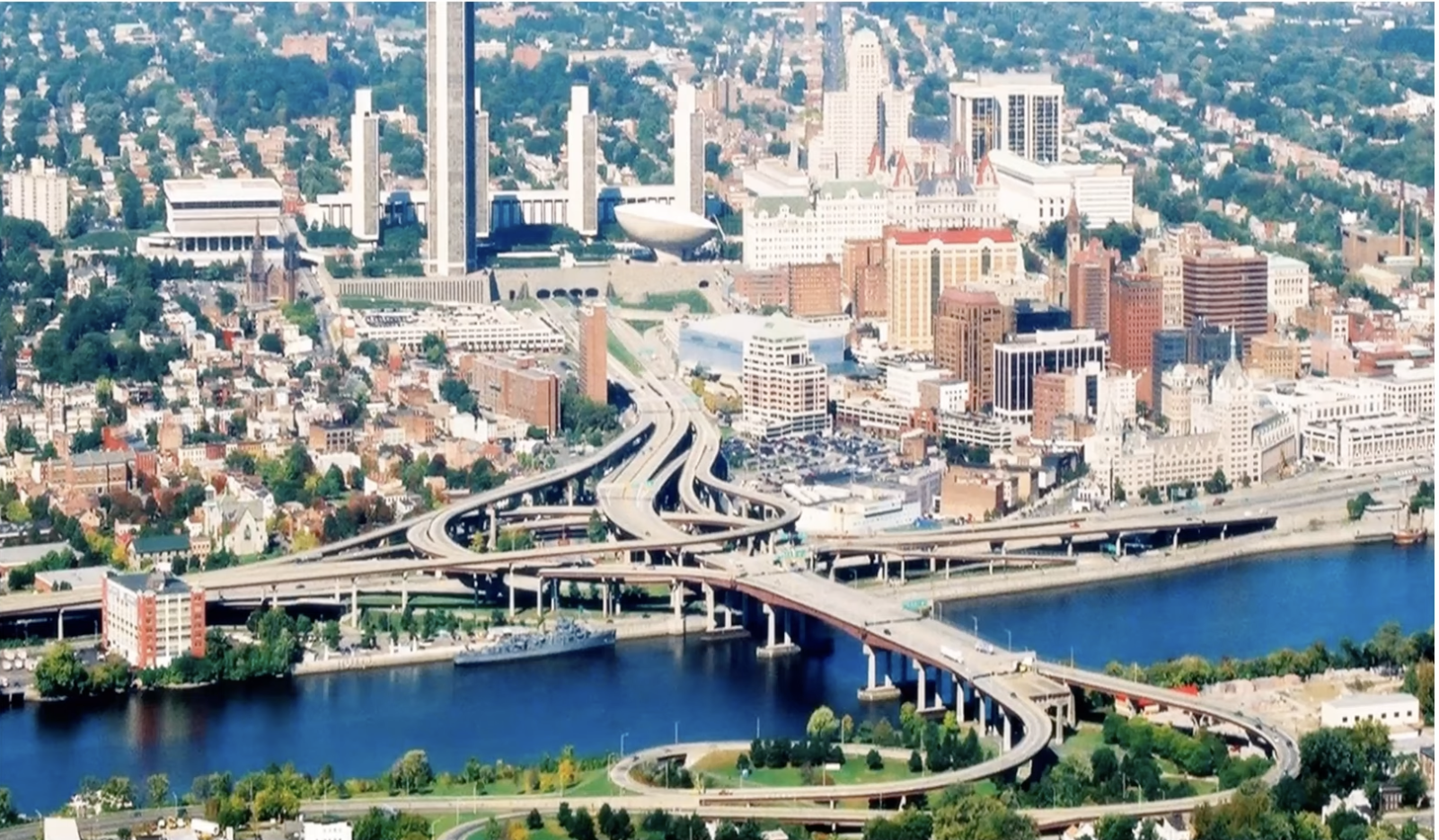
The City of Albany and the damage wrought by I-787 and the South Mall Arterial.
SCOTT TOWNSEND, a principal at 3tarchitects and one of the founders of the Albany Riverfront Collaborative, described how the city is at the "raw beginning of their journey," in grappling with its waterfront, I-787, and the South Mall Arterial, which runs into Empire Plaza, despite the fact that multiple engineering and feasibility studies on the waterfront have been performed over the past two decades. Like others on the panel, Mr. Townsend said that something critical has changed in the last year, including a tsunami of press coverage and public attention and the potential availability fo federal funds, that may finally get the city over the hump on inaction to finally doing something.
Despite this, Mr. Townsend acknowledged that Albany's waterfront is a bigger behemoth than other projects. There are major technical considerations, including a rail line, but perhaps the biggest barrier is the challenging political environment in Albany, a city which, as Mr. Townsend said, "waits to be told what to do" and often lacks the activation energy that some of the other upstate cities have. Thus, one of the roles of the Riverfront Collaborative is to identify "the obstacles of coming together."
The Albany Riverfront Collaborative sees the waterfront project not as a transportation project, but as a community development project that will reconnect the city to its waterfront and the South End to the city. "There is a transportation component," said Mr. Townsend. "But at is heart this is about addressing socioeconomic equity, public health, and climate change." Mr. Townsend pointed to the South Mall Arterial, which effectively severed the South End from the rest of Albany, as perhaps the most pernicious piece of racist infrastructure in the whole area.
"But we can't get in line for any of this spending if we don't have some sort of plan in place," he said. The Riverfront Collaborative is taking an inclusive and collective approach, inviting all parties in, while entertaining multiple visions. So far possible solutions include bringing the water into the city by a canal, boulevarding the highway and raising the railways, or creating a "cap park" over the highway.
"None of these ideas are mutually exclusive," stressed Mr. Townsend.

The South Mall Arterial bisects Downtown Albany (left) and the South End (right).
—
Following the presentations, our conversation (with audience Q&A) covered a lot of ground, including how to manage the ecological implications for highway removal to combat the climate crisis; how the momentum has changed in terms of federal funding; how to encourage small business and community entrepreneurship; how to meet people where they are, particularly communities of color; how to develop common, positivist language; how to work with DOT and not against them; and how to heal longterm community damage done by urban highways.
"Highway removal is not a technical issue—we know how to do it—it's a political issue. It's a coalition-building issue," said Mr. Crowther.
To see the full video of the event, click on the video image below.